-Up to 66.6 g/t gold in boulders – 8 km-long potential source area identified-
-Regional sampling also identifies new mineralization in three new areas, up to 24.4 g/t gold in outcrop-
Vancouver (November 13, 2018) Solstice Gold Corp. (TSXV: SGC) (“Solstice”, the “Company”, “we” or “our”) is pleased to provide updated results from the summer, 2018 work program at its 100% owned 920 km2 Kahuna Gold Project (“Kahuna” or the “Project”), located near Rankin Inlet, Nunavut. The objectives of the 2018 program were to identify targets for potential drill follow up and also to prospect under-explored parts of the large project area.
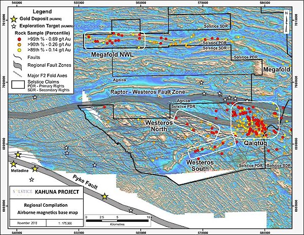
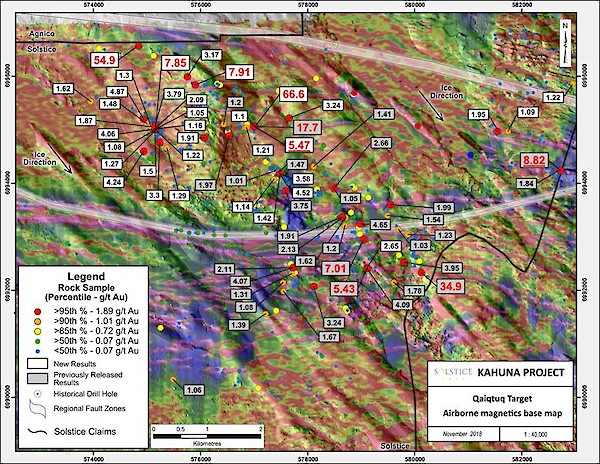
This news release summarizes results of regional sampling conducted during 2018 (Figure 1) and focusses on the Westeros area where detailed sampling has now outlined a 15 km2 area of gold-bearing boulders and, locally, gold in outcrop, referred to as Qaiqtuq target (Figure 2). Highlights include:
- A maximum gold value in sampled boulders of 66.6 g/t1 gold from a grab sample collected by Roscoe Postle Associates (“RPA”) taken during their field inspection in September 2018 (this sample was collected from a boulder that previously assayed 17.7 g/t gold). Other significant gold values include 54.9 g/t (boulder), 34.4 g/t (boulder) and 24.4 g/t (outcrop) gold.
- A grab sample of silicified iron formation in outcrop, taken within metres of the 66.6 g/t gold in boulder grab sample, returned 5.74 g/t gold. Most boulders come from areas interpreted to be locally sourced (see discussion below).
- Gold is associated with sulphide mineralization including locally coarse grained arsenopyrite (typically 1-5%, locally up to 30%). The association of gold with significant arsenopyrite is documented from gold deposits in the region. Host rocks are dominantly iron formation with subordinate mineralized metasediments.
- The main area of gold-bearing boulders occurs adjacent to a north-south ridge which is up to 70m high. The ridge comprises outcrop, subcrop and locally sourced boulder fields. It is cut by distinctive east-west trending gullies (possible faults) visible on aerial photographs and on the ground.
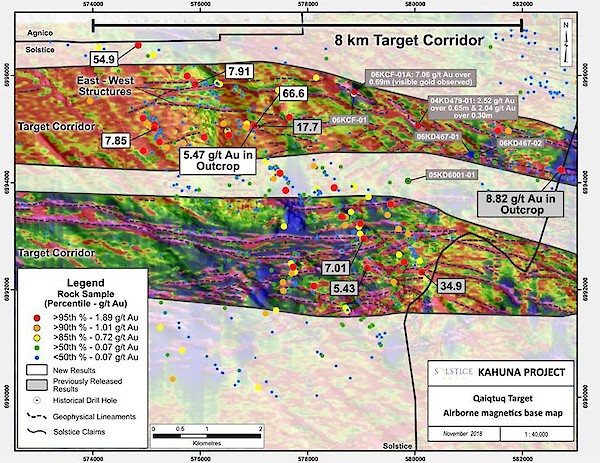
- The Qaiqtuq target area is associated with east-west structures and largely coincident trending magnetic (Figure 3) and electro-magnetic (em) anomalies (see corporate presentation at www.solsticegold.com for em map).
- Table 1 provides a summary of sample data from the project and each of the specific target areas shown in Figure 1.
The Company believes that most of the boulders are locally sourced and likely related to the east-west magnetic and possible fault structures present in the area for the following reasons:
- Angular and generally friable nature and large size of the boulders (see Company website for photos).
- Proximity of boulder clusters to the outcrop/subcrop ridge.
- Proportion of mineralized boulders within boulder field areas (up to 20%).
- Presence in outcrop of mineralized iron formation in three locations (see discussion, below) and its association with coincident east-west trending magnetic anomalies and mineralized boulders in the interpreted source area.
- Confirmation of in situ mineralized and gold-bearing iron formation in two short (45.1 m and 47.9 m) historical drill holes completed in 2004 and 2006 located east of, and on strike to, the boulder field.
“Our objective at the start of this year was to identify targets for diamond drilling - this objective has been met. We expect the Qaiqtuq target area to be the focus of our exploration for some time to come. The setting and tenor of mineralization at Qaiqtuq, including the association with coarse grained arsenopyrite and the proximity to major faults zones, all important elsewhere in the region, are very encouraging” Stated David Adamson, Executive Chairman.

Figure 1: Regional compilation of the Kahuna project. Base map is RTP (Reduced to Pole) shaded airborne magnetic data. Data outside Solstice claims are derived from assessment files, and GSC open files 6606 & 6616. Gold data and structural interpretation is by Solstice. Gold deposits and exploration targets are from the Nunavut Minerals (NUMIN) database.

Figure 2: Qaiqtuq target area. Base map is 1st vertical derivative airborne magnetic data, Solstice sampling and structural interpretation. Historical drill holes are colour coded based on the rock sample percentile legend and the historical gold values reported in the drill holes. Underlined gold values represent grab samples from outcrop. Percentile distribution is based on the Qaiqtuq target area (n=631).

Figure 3: Qaiqtuq target area. Base is 1st vertical derivative airborne magnetic data, Solstice sampling and structural interpretation. Historical drill holes are colour coded based on the rock sample percentile legend and the historical gold values reported in the drill holes (n=631).
The Qaiqtuq target lies within a regionally extensive fault system or break identified in regional mapping by the Geological Survey of Canada (Open File 5441, 2007), on neighbouring claims controlled by Agnico Eagle Mines Ltd (Nunavut assessment files assessment files) and by Solstice on its own claims. This break, similar to the Pyke fault to the south which hosts the Meliadine gold deposits*, has a clear, elevated magnetic signature extending over 10’s of kilometres. Solstice electromagnetic data in the area also clearly define major structures associated with the Westeros Break (See corporate presentation at www.solsticegold.com). Where mapped, the break is associated with highly deformed (strained) rocks.
Other regional targets
Reconnaissance-scale regional mapping and sampling have identified at least three new areas of gold mineralization on the property. These are shown in Figure 1, summarized in Table 1 and described below:
Megafold NWL is located on the Northwestern limb of a very large regional fold (see Figure 1). Grab samples (60 boulder and 131 outcrop samples of which a total of 21 (11%) contain >0.5 g/t gold) have returned a maximum value of 24.4 g/t gold from a 1 metre-wide quartz vein in iron formation outcrop. Mapping and magnetic data in the 5 km-long target area suggest the presence of numerous parallel and likely folded iron formation units.
Westeros North is located along the north limb of the Westeros fold which is interpreted to be coincident with regional fault structures. Grab samples over an area of 7 km x 3 km (73 boulder and 98 outcrop samples of which a total of 10 (6%) contain >0.5 g/t gold) include a maximum of 12.7 g/t gold from a boulder of quartz veined metasediments.
Westeros South is located on the southern limb of the Westeros fold where highly magnetic units are cut by faults. Grab samples over a strike length of 2 km, associated with a strongly magnetic underlying rock unit (77 boulder and 63 outcrop samples of which a total of 9 (6%) contain >0.5 g/t gold) include up to 11.66 g/t gold (grab sample by RPA, September, 2018).
“For the first time in the history of this area, our team has systematically mapped and sampled the project for its gold potential. We have discovered widespread gold in several areas of the property, in association with permissive hosts rocks that previously had no record of gold. Given the size of the property, sampling in these regional target areas is relatively wide spaced but results clearly warrant follow up. Through a combination of mapping, sampling and use of property-wide magnetic and electro-magnetic datasets, we have significantly advanced our understanding of the geological setting of the project. With a drill ready target at Qaiqtuq and the discovery of numerous new, regional targets, we believe this project represents a rare opportunity in an emerging and new gold district” stated David Adamson, Executive Chairman.
| Area | Type | Number of samples | Range g/t gold | 80th%ile | 90th %ile | 95th %ile |
|---|---|---|---|---|---|---|
Total project | Boulder (grab) | 1946 | 0.005-54.9 | 0.15 | 0.44 | 1.0 |
| Outcrop (grab) | 1536 | 0.005-24.4 | 0.04 | 0.11 | 0.29 |
Qaiqluq Target | Boulder (grab) | 613 | 0.005-54.9 | 0.44 | 1.01 | 1.89 |
| Outcrop (grab) | 18 | 0.005-5.47 | na | na | na |
Megafold NWL | Boulder (grab) | 60 | 0.005-5.79 | 0.11 | 0.36 | 1.73 |
| Outcrop (grab) | 131 | 0.005-24.4 | 0.20 | 0.55 | 0.95 |
Westeros North | Boulder (grab) | 98 | 0.005-6.47 | 0.08 | 0.16 | 1.03 |
| Outcrop (grab) | 73 | 0.005-12.7 | 0.02 | 0.06 | 0.18 |
Westeros South | Boulder (grab) | 63 | 0.005-0.816 | 0.04 | 0.14 | 0.42 |
| Outcrop (grab) | 77 | 0.005-3.6 | 0.08 | 0.29 | 1.32 |
Table 1: na- not relevant due to small population size n<30. See website for tabulation of all results.
1 Assay results from grab samples (boulders and outcrop) are selected samples and are not necessarily representative of the mineralization hosted on the property. Grab sample weights range from 0.75kg to 3kg.
*This news release contains information with respect to the Meliadine gold deposits owned by Agnico Eagle Mines, in respect of which the Company has no interest or rights to explore or mine. Readers are cautioned that the Company has no interest in or right to acquire any interest in any such properties, and that mineral deposits on adjacent or similar properties are not indicative of mineral deposits on the Company’s properties and there is no certainty of the same or similar deposits on the Company’s properties.
** Kaminak News Release, June 6, 2006 CCNMatthews. Solstice was not involved in the diamond drilling reported by Kaminak but has no reason to believe its QA-QC protocols as disclosed were not to industry standard. Solstice is in possession of the drill core and has reviewed the geological information from this drilling. Check sampling by Solstice on ¼ core of the reported intercept returned 1.91 g/t gold. While this is considered to confirm the presence of gold in the same core interval, results from 1/4 core sample using a standard 50g Fire assay analysis may not be directly comparable to the reported Kaminak sample which utilized the metallic screen Fire assay method which is commonly used where visible gold or nugget gold is present.
***Historical unreleased data from previous claim holder. Solstice was not involved in the diamond drilling but has no reason to believe its QA-QC protocols as were not to industry standard.
Rock Assay protocol
Rock samples are collected in plastic bags in the field and are shipped in secure bags using unique security coded tags to Activation Laboratories Ltd. In Thunder Bay Ontario, an accredited mineral analysis laboratory. All samples are analyzed for gold using a standard 50g fire assay technique. Samples returning over 3.0 g/t gold are analyzed using fire assay-gravimetric method.
About Solstice
Solstice is a new gold-focussed exploration company engaged in the exploration of its 920 km2 (100%) district scale Kahuna Project and certain other rights covering an adjacent 805 km2, all with no underlying option or earn in payments. Kahuna is located in Nunavut, Canada only 26 km from Rankin Inlet and approximately 7 km from the Meliadine gold deposits owned by Agnico-Eagle Mines Ltd. Solstice has 69.5 million shares outstanding.
Solstice is committed to responsible exploration and development in the communities in which we work. For more details on Solstice Gold and the Kahuna Project please see our Corporate Presentation available at www.solsticegold.com.
Neither TSX Venture Exchange nor its Regulation Services Provider (as that term is defined in the policies of the TSX Venture Exchange) accepts responsibility for the adequacy or accuracy of this release.
Ian Russell, P.Geo., Vice President Exploration, is the Qualified Person as defined by NI 43-101 standards responsible for reviewing and approving the technical content of this news release.
On Behalf of Solstice Gold Corp.
David Adamson, PhD
Executive Chairman
For further information please visit our website at www.solsticegold.com or contact:
Marty Tunney, PEng
President
info@solsticegold.com
Forward Looking Statements
This news release contains certain forward-looking statements (“FLS”) relating but not limited to the Company’s expectations, intentions, plans and beliefs. FLS can often be identified by forward-looking words such as “emerging”, “goal”, “plan”, “intent”, “estimate”, “expects”, “scheduled”, “may” and “will” or similar words suggesting future outcomes or other expectations, beliefs, plans, objectives, assumptions, intentions or statements about future events or performance. FLS in this news release also include, but are not limited to, the extent and timing of described programs and ground work, such as rock sampling, drilling, till sampling and analysis. FLS in this news release include comparison with certain geological features at an adjacent development property. There can be no guarantee that continued exploration at Kahuna, which is at an early stage of exploration, will lead to the discovery of an economic gold deposit. Factors that could cause actual results to differ materially from any FLS include, but are not limited to, delays in obtaining or failures to obtain required governmental, environmental or other project approvals, inability to locate source rocks, inflation, changes in exchange rates, fluctuations in commodity prices, delays in the development of projects, regulatory approvals and other factors. While the Company believes the boulders are sourced locally for the reasons outlined in this news release, there can be no certainty that their source is local, or that it will be located on Solstice claims. FLS are subject to risks, uncertainties and other factors that could cause actual results to differ materially from expected results.
Potential shareholders and prospective investors should be aware that these statements are subject to known and unknown risks, uncertainties and other factors that could cause actual results to differ materially from those suggested by the FLS. Shareholders are cautioned not to place undue reliance on FLS. By their nature FLS involve numerous assumptions, inherent risks and uncertainties, both general and specific, that contribute to the possibility that the predictions, forecasts, projections and various future events will not occur. Solstice undertakes no obligation to update publicly or otherwise revise any FLS whether as a result of new information, future events or other such factors which affect this information, except as required by law.
This news release contains information with respect to adjacent or similar mineral properties in respect of which the Company has no interest or rights to explore or mine. Readers are cautioned that the Company has no interest in or right to acquire any interest in any such properties, and that mineral deposits on adjacent or similar properties are not indicative of mineral deposits on the Company’s properties. Past performance is no guarantee of future performance and all investors are urged to consult their investment professionals before making an investment decision. Investors are further cautioned that past performance is no guarantee of future performance.
Solstice has contracted an independent geophysical consultant to oversee and review and advise the Company on all geophysical surveys of the Property.

