Drill Targets Developing for 2022 Exploration Program
VANCOUVER, British Columbia, March 14, 2022 - Solstice Gold Corp. (TSXV: SGC) (“Solstice”, “we”, “our” or the “Company”) is pleased to announce results of airborne electromagnetic (“EM”) surveys and soil sampling at our RLX Gold Project (“RLX”), located in the northwestern extension of the prolific Red Lake Gold Camp (the “Camp”). The 2021 field results have outlined four key target areas with gold in soil anomalies as well as geological, geophysical, and geochemical settings that are consistent with other deposit areas in the Camp. The Company plans to test these targets in 2022 starting with a 5,000 metre, permitted and fully funded drill program. Based on a compilation of the new data, we have recently extended our land position from 5.5 km2 to 11 km2 with new staking to secure additional prospective ground.
Summary of Results
- Combined EM, soil and geological data reveal approximately 16km of strike potential within a largely unexplored extension of the Red Lake Gold Camp.
- Strongly elevated gold and spatially associated soil pathfinder elements combined with EM and structural interpretations define numerous target areas in several settings.
- EM response within the project is widespread and variable with subdued conductivity in areas of elevated soil geochemical responses. This may indicate alteration of host conductive units by later processes associated with mineralization. NE-trending conductors are present in several areas which correlate with interpreted, and locally observed, NE-trending geological features which cut the regional NW trending fabric. Areas of strong conductivity are present including some outside of known greenstone belts.
- NE-trending structures with an interpreted extensional component may provide support for the presence of a major crustal fault (“E1”) as interpreted from seismic data1. In February 2021, the Ontario Geological Survey (“OGS”) drew attention to regional seismic structures surfacing in the area of RLX noting that two other similar structures are associated with important gold deposits in the Camp2.
Mike Timmins, Solstice’s Chief Executive Officer, stated, “Our goal in Red Lake is to make a discovery outside of the traditional mine trend in areas of the Camp which are meaningfully underexplored. Last year’s fieldwork has generated several exciting target areas which will now be drill tested systematically for the first time. We are fortunate to be one of only a few groups with a significant land position, momentum building as we continue to outline potential and an exciting exploration program about to begin. We look forward to releasing additional detail on each of these prospective target areas in the coming weeks and prior to the commencement of drilling in the spring.”
DETAILED REVIEW OF RESULTS OF TECHNICAL PROGRAMS
Background
As outlined in our news release dated January 10, 2022, government and researchers, using seismic data have pointed to the potential presence of major, crustal scale south-dipping normal or extension faults in the vicinity of RLX denoted as E1 and E2 in the literature. In February 20212, the OGS drew attention to two other similar features further south in the Camp that are associated with important gold deposits and/or mines. During 2021, we carried out geological, soil (humus) sampling and magnetic/EM surveys. The integrated results of these programs, detailed below, define numerous target areas over a combined 16km strike length.
David Adamson, Ph.D., Solstice’s Chairman, stated, “Our experience in Red Lake, including directly along strike of RLX, gives us confidence that we control an essentially unexplored, extension of the prolific Red Lake Gold Camp. Third party data suggests major, deep-seated structures should be present in the area and we may be seeing evidence for these locally. Systematic exploration at RLX, including geological mapping, magnetic, EM and soil surveys, confirm the prospective setting for gold mineralization and the objective of our upcoming drill program will be to confirm this. It should be noted that, further north, we also control the 11 km long New Frontier property, where a second deep structure is inferred by the OGS and others. We will be carrying out field work in this area in 2022 using experience gained from RLX.”
EM surveys outline extensive, variable conductivity and subsidiary NE-trending anomalies.
In November 2021, we carried out magnetic and EM surveys designed to support geological mapping over the property due to limited surface rock exposure and to investigate the potential for mineralization associated with, or near, conductive features. Our model is based on other gold occurrences in the district including the Sidace Gold Deposit (Evolution Mining – 53.3% - Pacton Gold 46.7%), The PureGold Mine (Madsen) and other more recent examples. In the Camp, conductive features themselves can be gold-bearing or can serve as markers to aid in vectoring towards parallel or associated targets.
An example of the conductive response at 80 metres below surface, integrated with our structural modelling, is provided in Figure 1 which shows the following:
- Regionally extensive conductors developed over a 16km strike length displaying variable conductivity and interpreted to mark the widespread presence of Red Lake geology.
- Conspicuous NE-trending conductors are associated with NE-trending faults, e.g, South Target area (Figure 1). Faults in this area can be traced southwestwards to the Sidace Gold Deposit area. Many of the NE structures are interpreted to be extensional and could be evidence supporting the regional E1 structure interpreted by third parties from seismic data1,2.
- The conductive sequence lies adjacent to the regionally extensive Nungessor Shear Zone (“NSZ”), mapped by the OGS. This feature, which can be traced northwards for at least 80km is also a candidate for the surface expression of the seismically interpreted E1 feature although further north, on our New Frontier project, the OGS interpret the NSZ as the second major seismic structure, E2 (News Release dated January 10, 2022).
Figure 1 shows historical diamond drill holes in the area (Dome Exploration Canada – Placer Dome, 1980). These holes were shallow and only sparsely sampled but out of twelve holes, two recorded elevated gold over narrow widths (two intervals of 0.68g/t over 1.52m in hole B6 and 1.68g/t over 0.68m in hole B7). Four holes did not adequately explain their geophysical target and one was sampled but did not report assays in filed assessment work. Two drill holes reported sericite schist and/or skarn units which are important hosts rocks at Sidace and elsewhere in the Camp. As was the case in the Sidace area, which subsequently has seen more than 80,000 metres of drilling, Placer Dome did not follow up on these early signs of prospectivity.

Figure 1. -80m conductivity slice of EM 3d voxel with fault interpretation on shadowed regional OGS magnetic base. Area of new staking shown in yellow covering fault extensions. Nungessor Shear Zone from OGS mapping. Areas of potential seismic structures shown as E1 and E2 on inset map.
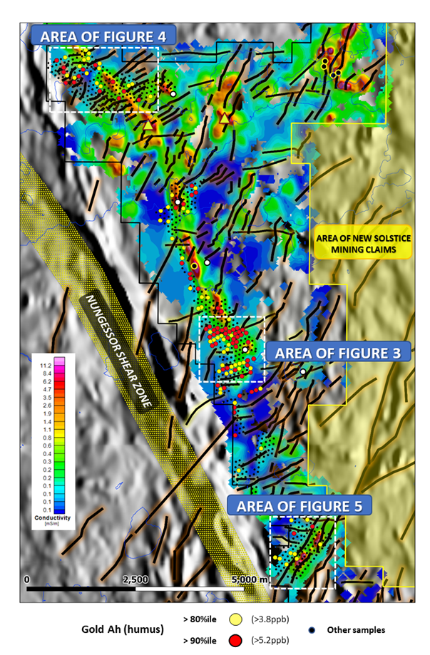
Figure 2. Elevated Gold in soils (humus) plotted on the -80m conductivity slice with fault interpretation on shadowed regional OGS magnetic base. Area of new staking shown in yellow covering fault extensions.
Soil Sampling outlines elevated gold and pathfinder elements in several areas.
In early summer 2021, we carried out test humus soils sampling over selected parts of the property. This work was successful in defining areas with anomalous gold plus specific pathfinder elements arsenic, molybdenum, mercury, and antimony (News Release dated September 8, 2021). Based on these positive results, we expanded soil sampling in late 2021 to include other accessible parts of the property. Results for gold are summarized in Figure 2 with further detail provided for three sub-areas in Figures 3 to 5.
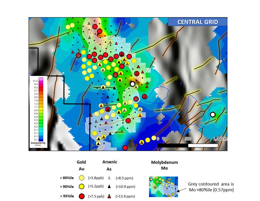
Figure 3. Central Grid Ah (humus) gold-arsenic-molybdenum soils plotted on -80m conductivity slice fault interpretation on shadowed regional OGS magnetic base (scale as in Figs 1 and 2). See text for further details.
Discussion of Soil Data
Three main areas of elevated gold and pathfinder elements are present in the Central, North and South grid areas (see Figure 2). These are summarized below:
Central Grid – See Figure 3
- This is a 1.3km x 0.9km area containing elevated gold +/- arsenic anomalies with flanking elevated molybdenum. Other anomalous elements (not shown) include antimony and mercury.
- Numerous elevated gold samples in this area have values greater than the 95th percentile of the data (N=711). While it is not possible to directly compare these absolute values with other gold-bearing areas outside of RLX, experience and third-party examples suggest that the 95th percentile value of >7.5ppb Au is meaningful. Eight samples in this area contain >10ppb Au of which six have >15ppb (max = 19.2ppb Au). Arsenic and molybdenum values in the central area range up to 30.3ppm and 1.78ppm, respectively. Summary statistics for all elements described in this news release are presented in Table 1.
- Conductivity in the area, while present, is reduced in areas of elevated soils which may indicate alteration of primary conductive units.
- Several E-NE-trending interpreted structures are visible in magnetic data in the vicinity of the elevated soil data.
- The area lies immediately east of a “Sanukitoid” gabbro body mapped and sample by the OGS. This intrusive rock type is diagnostic of a mantle derivation which suggests it tapped very deep structures and as such is further supporting evidence for the presence of crustal scale faults in this area. East of the elevated soil responses is an area of very elevated magnetic response of unknown origin.
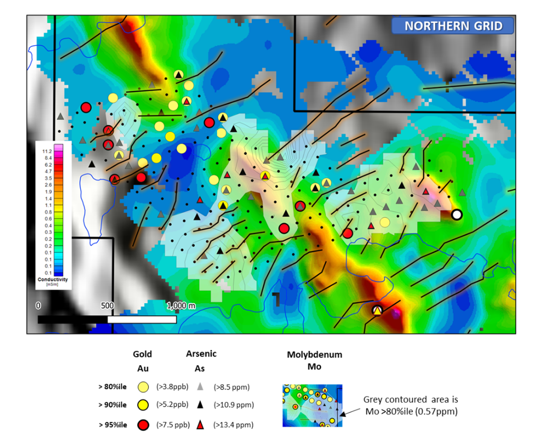
Figure 4. North Grid Ah (humus) gold-arsenic-molybdenum data on -80m conductivity slice with fault interpretation on shadowed regional OGS magnetic base. See text for further details.

Figure 5. South Grid Ah (humus) gold-arsenic-antimony-molybdenum soils on -80m conductivity slice of EM 3d voxel with fault interpretation on shadowed regional OGS magnetic base. See text for details.
North Grid – See Figure 4
- This area shows two sub areas of gold-arsenic and, to its south, gold-arsenic-molybdenum anomalies which, collectively define a 1.7km x 0.9km area. Other anomalous pathfinder elements in this area include antimony and mercury.
- The two areas referred to above are separated by a conspicuous NE-trending break in conductivity which may correlate with a structure (fault).
- Notable soil samples in this area include gold, arsenic and antimony with maximum values of 19.7ppb, 48.6ppm and 24.6ppm, respectively. See Table 1 for complete summary statistics.
- Sampling does not extend to the northwest and where conductivity data suggest the geological trend continues.
South Grid – See Figure 5
- This area of soils is marked by conspicuous NE-SW trending conductors which correlate with regional-scale magnetic features interpreted as normal (extensional) faults. Unlike the rest of the property, this is an area where a minor amount of outcrop exists and where NE-trending foliations are mapped defining a NE-SW-trending F2 fold axis, oriented approximately 90 degrees to regional NW-trending (F1) structures.
- Multi-element soil anomalies are present in this area but are not as strong as in the central and north target areas. However, 3D EM data suggest that near surface conductivity is low and that the EM conductor in this area improves with depth. It is possible therefore that this area is exhibiting a muted soil near surface response as a result.
There are other areas of elevated gold in soils not reviewed here and extensive parts of the property could not be sampled due to lack of available humus or access issues. One notable example is the strong area of conductivity in the NE area (Figure 1) which has only limited access for soil sampling, but remains a key target area.
Summary
- Taken together, soils, EM and structural interpretations define numerous target areas. Gold in soils are typically associated with other pathfinders which would be predicted by our exploration model (e.g., arsenic, molybdenum, antimony, mercury).
- EM responses across the project are varied. Often, but not always, EM is reduced in areas of anomalous soils compared to areas along strike which may indicate secondary alteration of host conductive units by later processes. Several areas display NE-trending conductors which are correlated with interpreted and locally mapped NE-trending geological features.
- NE-trending structures are interpreted to have an extensional component and may provide support for the presence of extensional features associated with the major E1 extensional structure identified from seismic data2
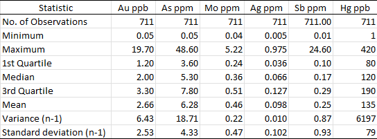
Table 1. Summary statistics of selected elements
1 Calvert, Andrew J. and Cruden, Alexander R. 2004. Seismic evidence for the preservation of the Archean Uchi granite-greenstone belt by crustal-scale extension. Tectonophysics 388 p.135-143
2 Lewis, S.O. 2021. Deep tapping seismic structure in the Red Lake district; in Ontario Geological Survey, Resident Geologist Program, Recommendations for Exploration 2020-2021, p.9-13.
Soil Sampling Protocols
Sampling and QC analysis of samples was carried out under the supervision of independent consultant Colin Dunn P.Geo, Ph.D, an acknowledged expert in this field. Prior to carrying out the survey, various sampling and analytical protocols were reviewed in conjunction with Dr. Dunn whose recommendation was that Ah (humus) sampling and standard Aqua Regia digestion were the preferred methods based on ground conditions and available material. An approximately 150 g sample of Ah (humus) soil was collected in standard kraft sample bags at 100 metre centres using protocols established by Dr. Dunn. Solstice staff were supported in the field in phase one sampling by WellDunn Consulting of Calgary, Alberta (independent of Dr. Colin Dunn and Solstice). An initial batch of approximately 300 samples were shipped to Dr. Dunn at his preparation facility following which they were sieved to approximately 50 mesh (297um) to remove extraneous materials. Remaining samples were prepared by Activation Laboratories Ltd. (Actlabs) of Ancaster Ontario using protocols established by Dr. Dunn. At Actlabs, 0.5g of sample material was digested using Aqua Regia and subsequently analyzed by ICP_MS for 63 elements (package UT1). In addition to internal Actlabs controls, field duplicate and internal (‘blind’) controls were inserted into the sample stream. Actlabs is independent of Solstice and its consultants. Quality control of data and verification was carried out by Colin Dunn and was reviewed and approved by Sandy Barham P.Geo. designated QP.
Airborne EM survey details
The 879.1 line km SkyTEM electromagnetic and magnetic survey was flown by SkyTEM Surveys ApS using the SkyTEM312M system between November 5-15, 2021 at a nominal 75m line spacing. Data products include processed electromagnetic data and presentations, spatially constrained inversion results and model presentations as well as processed magnetic data and presentations. These products are being further reviewed with our third-party geophysical consultant to include generation of 3D inversion magnetic, electromagnetic and other products models to aid drill targeting.
About Solstice Gold Corp.
Solstice is a gold-focused exploration company with quality, district-scale projects in established mining regions of Canada. Our 180 km2 Red Lake land position is located on the northern extensions of the prolific Red Lake Gold Camp in Ontario. RLX is approximately 45km from the Red Lake Mine Complex owned by Evolution Mining. The Company is funded for phase one drilling in Red Lake. Our newly formed 225km2 Atikokan Gold Project is approximately 23km from the Hammond Reef Gold Project owned by Agnico Eagle Mines Limited and is fully funded for a robust field program in 2022. Our district scale Qaiqtuq Gold Project which covers 886 km2 with certain other rights covering an adjacent 683 km2, hosts a 10 km2 gold boulder field and is fully permitted with multiple drill-ready targets. Qaiqtuq is located in Nunavut, Canada, only 26 km from Rankin Inlet and approximately 7 km from the Meliadine gold deposits owned by Agnico Eagle Mines Limited.
Solstice is committed to responsible exploration and development in the communities in which we work. For more details on Solstice Gold, our exploration projects and details on our recently acquired portfolio of projects please see our Corporate Presentation available at www.solsticegold.com.
David Adamson was a co-award winner for the discovery of Battle North Gold Corporation's Bateman Gold deposit and was instrumental in the acquisition of many of the district properties in the Battle North portfolio during his successful 16 years of exploration in the Red Lake.
Sandy Barham, M.Sc., P.Geo., Senior Geologist, is the Qualified Person as defined by NI 43-101 standards responsible for reviewing and approving the technical disclosures of this news release.
Neither TSX Venture Exchange nor its Regulation Services Provider (as that term is defined in the policies of the TSX Venture Exchange) accepts responsibility for the adequacy or accuracy of this release.
On Behalf of Solstice Gold Corp.
Mike Timmins, Chief Executive Officer
For further information on Solstice Gold Corp., please visit our website at www.solsticegold.com or contact:
Phone: (604) 283-7234
Forward-Looking Statements and Additional Cautionary Language
This news release contains certain forward-looking statements (“FLS”) including, but not limited to the Company’s plans to start testing targets in 2022 including fully funding a drill program and carrying out field work in Red Lake. FLS can often be identified by forward-looking words such as “approximate or (~)”, “emerging”, “goal”, “plan”, “intent”, “estimate”, “expects”, “potential”, “scheduled”, “may” and “will” or similar words suggesting future outcomes or other expectations, beliefs, plans, objectives, assumptions, intentions or statements about future events or performance. There is also no guarantee that continued exploration at Solstice exploration projects, all of which are at an early stage of exploration, will lead to the discovery of an economic gold deposit. Factors that could cause actual results to differ materially from any FLS include, but are not limited to, the future impacts of the COVID 19 pandemic and government response to such pandemic, the ability of the Company to continue exploration at its projects during the pandemic and the risk of future lack of access to the projects as a result thereof, delays in obtaining or failures to obtain required governmental, environmental or other project approvals, inability to locate source rocks, inflation, changes in exchange rates, fluctuations in commodity prices, delays in the development of projects, regulatory approvals and other factors. FLS are subject to risks, uncertainties and other factors that could cause actual results to differ materially from expected results.
Potential shareholders and prospective investors should be aware that these statements are subject to known and unknown risks, uncertainties and other factors that could cause actual results to differ materially from those suggested by the FLS. Shareholders are cautioned not to place undue reliance on FLS. By their nature FLS involve numerous assumptions, inherent risks and uncertainties, both general and specific, that contribute to the possibility that the predictions, forecasts, projections and various future events will not occur. Solstice undertakes no obligation to update publicly or otherwise revise any FLS whether as a result of new information, future events or other such factors which affect this information, except as required by law.
This news release contains information with respect to adjacent or other mineral properties in respect of which the Company has no interest or rights to explore or mine or acquire. Readers are cautioned that mineral deposits on adjacent or similar properties are not indicative of mineral deposits on the Company’s properties, nor is there certainty that Solstice’s projects will contain economic mineralization. This news release mentions other companies that are unrelated to Solstice, and this does not imply any agreements, partnerships, or rights with respect to any of these companies or their properties other than where explicitly defined. Past performance is no guarantee of future performance, and all investors are urged to consult their investment professionals before making an investment decision.