Atikokan Gold Project
Our Atikokan Gold Project in the Hammond Gold Camp near Atikokan, Ontario is 225km2 and has grown considerably from the original holdings which formed part of the recently acquired royalty and property portfolio (see news release of September 15, 2021). Key highlights are summarized below:
Key Project Highlights
- A rare opportunity to control district scale land position in an Archean gold camp
- Proximity to Agnico Eagle’s Hammond Reef1 project and potential future production capacity
- Excellent project infrastructure and experienced exploration services
- Exposure to the growing value of investment into an emerging high-grade camp
- Grassroots exploration over large regional structures to begin summer 2022
Solstice identified the Hammond Gold Camp as an emerging gold district because it is has demonstrated prospectivity beyond Agnico Eagle’s Hammond Reef gold deposit. In recent years, new discoveries, and data, including our own field-based due diligence in 2020, confirm the presence of multiple, prospective mineralized structures in similar host rocks.

Regional Geological Setting
The Solstice land package is largely underlain by the 3-billion-year-old, 100km long Marmion Intrusive Complex (“MIC”) which also hosts the Hammond Reef gold deposit. The MIC is traversed by numerous NE and NNE structures which are readily identifiable on magnetic and topographic maps. These are likely long-lived structures but locally are splays off the regional east-west, Quetico fault which bounds the MIC to the south. Known mineral deposits in the belt and recent discoveries are closely associated with these NE to NNE structures and are typically associated with appreciable quartz veining with low to variable amounts of sulphides.
Local Evidence for Mineralized Structures
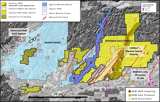
At Jackpine, preliminary due-diligence mapping by Solstice in 2020 identified a 1000m2 area of 100% quartz mineralization (open in all directions) within the Jackpine structure which points to robust fluid flow in an extensional setting. Preliminary sampling by the Sellers of Night Sky in 2021 had identified widespread sulphide mineralization associated with the Mercutio Lake structure which is also believed to trend onto our 100% claims at Jackpine. Recently reported sampling by Agnico Eagle in 2020 (MNDM assessment files) has documented gold along the very extensive NE-trending Melema Lake structure (Figure 1).
Lake sediment sampling by the OGS2 show that many known gold occurrences in the region are associated with elevated gold in lake sediments. Significantly, there are numerous unexplained gold anomalies, especially in the eastern area of the Solstice claim block (Figure 1). We suspect these may be associated with prominent NNE faults and thus they represent priority areas for follow-up.
Taken together, our view is that it is becoming increasingly clear that there are numerous, previously unrecognized structures, including many on our extensive land holdings which have received little or no exploration. These represent exciting exploration targets.
Project Infrastructure
The claims are road accessible via Trans Canada Highway 11 located ~5km to the south. Local infrastructure includes logging roads, rail, gas and hydro power and an experienced mineral exploration workforce and mining supply, all located within hours of the property.
1 Reference to https://www.agnicoeagle.com/English/operations/reserves-and-resources/default.aspx
2 Ontario Geological Survey 2000. Atikokan area lake sediment survey: Au and PGEs – Operation Treasure Hunt; Ontario Geological Survey, Open File Report 6034, 62p

